18 August 2015

Update #2 to Google Maps Directions to GPX data

I've applied several major updates to the tool discussed in this article. Update #1Update #2Update #3, Update #4 and Original post.

The Google Maps Directions to GPX has received its second update.

Try it

Change log

  • Support for short urls (e.g. "goo.gl/maps/..." links).
  • Support for multi destination directions.
  • Waypoints will now get a full address into their <desc> field if available.
  • Option to exclude creation of waypoints (external to the route).
  • Option to provide a custom name for the route.
  • Improved error handling and validation of Google Maps links.
  • Addressing an issue where if URL is missing sections the Google service will estimate the destination (this will most likely cause an incorrect route to be generated).


Changes to JSON output only 

These have not yet been integrated into the GPX format.
  • Inclusion of Google StreetView imagery where available.
  • Preliminary support for elevation profile data (only for walking and cycling directions).
  • Turn information available in markup format ("step" field).
  • List of all countries the route passes through.
  • List of all destinations in route (in addition to start and finish).

Try it


Map Link with Multi Destination Directions

Map Link with Cycling Directions (will have elevation data)

16 August 2015

Update #1 to Google Maps Directions to GPX data

I've applied several major updates to the tool discussed in this article. Update #1Update #2Update #3, Update #4 and Original post.

In a previous post I shared an experimental tool that I had been tinkering with that converts Google directions to GPX format.

After quite a few interesting suggestions and discussions with readers I want to present Update #1 to this tool.

Try it


Major changes

  1. New and more user friendly UI with error checking.
  2. More control over output format and output file types (the tool now defaults to generating a file that has the broadest compatibility with the GPX standard).
  3. Auto-generation of unique route point names (format "RPxxx").
  4. Option to include the full direction text with each route point in the <desc> field.
  5. Option to include a brief next turn information with each route point in the <cmt> field.
  6. Optional JSON response for future web-development
The new UI with all options

Try it

11 July 2015

Updating the ESA Small & Medium Sized Enterprises map (#3)

Since I created the ESA contractor map in November I've been surprised to see that I seem to get regular traffic to it.

I must admit that when I built this first I was not concerned with tracking how often the underlying SME database changes on the ESA side and the project doesn't really have any built in stats tracking that (yet).

Neither have I found time to fully automate the extraction and parsing of the data from the SME database. This code to produce and prepare the background data all lives in a C# application that currently I need to run manually to get the updated lists of companies and fields.

Out of curiosity I decided to run an update on the underlying data today and was surprised at the number of new and updated entries that were located.

View Latest

The Changes

All in all there where 39 major changes to the registry including new, deleted and updated companies.

I've updated the map markers and fixed a few minor bugs relating to mobile clients.

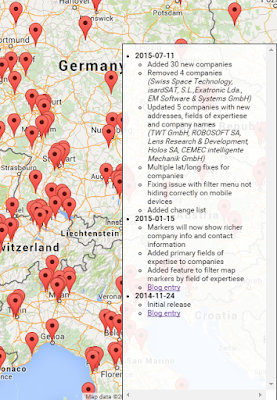
I also introduced a change list section. This section is shown in the lower right hand corner of the map and lists the changes that I have made to the map source data.

I should do this to all of my applications actually, it is really handy to track what has changed and when.


A version of this article is also available on LinkedIn
https://www.linkedin.com/pulse/esa-small-medium-sized-enterprises-interactive-map-sigmundarson